Planning for sea level rise in rural communities is a diverse challenge, and the Planning for Coastal Change in Levy County project has responded with diverse solutions. Most recently, the Yankeetown-Inglis Adaptive Design Report puts forward possible adaptation strategies for coastal change that are specific to the towns of Yankeetown and Inglis. This first step to understanding the potential spatial implications of sea level rise projections will enable the communities to further consider a range of options for adaptation.
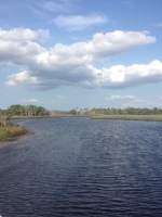
The report covers the research process used to gather and analyze geographic and demographic data, modeling results, and public input, which resulted in multiple, interrelated adaptive design strategies. The adaptive design strategies are tailored to six identified geographic areas, called Adaptation Areas (AA’s). The AA’s differ in their adaptation requirements due to factors such as position in relation to water, topography, storm surge risk, existing infrastructure and development, and jurisdictions and current land use policies. The report also presents many informative maps, photographs displaying the distinctive character and ecology of both Yankeetown and Inglis, a glossary of important terminology, and an appendix further illustrating many adaptation strategy examples.

Identified Adaptation Areas in Yankeetown and Inglis, Florida